New Orleans Floods As Gulf Coast Braces For Torrential Rains
(The Advocate via AP)
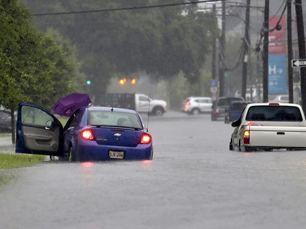
Floodwaters swamped streets in New Orleans‘ French Quarter on Wednesday and prompted a tornado warning in the area amid concerns that even worse weather is on the way to Louisiana and other states along the Gulf of Mexico.
The storms were associated with a broad area of disturbed weather in the Gulf that’s expected to become better organized by this weekend when it threatens the region with torrential rain.
Once it becomes better organized, the weather system could push the already swollen Mississippi River precariously close to the tops of levees that protect New Orleans, forecasters said.
The low pressure area Wednesday was over water, south of the Florida Panhandle. It was expected to strengthen into a storm as it moved west through the Gulf’s warm waters.
Lines of thunderstorms associated with the system on Wednesday extended far out in into the Gulf and battered New Orleans, where at least 3 inches (7.6 centimeters) of rain had fallen by mid-morning.
It’s expected to get much worse in the days ahead.
Parts of Louisiana could see up to 12 inches (30 centimeters) of rain by Monday, with heavier amounts possible in some spots, forecasters said.
Mississippi and Texas were also at risk of torrential rains.
The National Weather Service said New Orleans is protected to a river level of 20 feet (6.1 meters), but it was forecast to rise above flood stage to 19 feet (5.8 meters) by Friday.
[ione_media_gallery id=”168903″ overlay=”true”]