
SANTO DOMINGO, Dominican Republic (AP) — A strengthening Hurricane Maria churned toward the Leeward Islands in the eastern Caribbean on Monday as forecasters warned it was expected to become a major hurricane by early Tuesday.
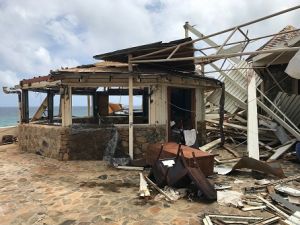
Maria swiftly grew into a hurricane Sunday, and forecasters said it was expected to become much stronger over the coming hours following a path that would take it near many of the islands wrecked by Hurricane Irma and then on toward Puerto Rico, the Dominican Republic and Haiti.
Hurricane warnings were posted for Guadeloupe, Dominica, St. Kitts, Nevis, Montserrat and Martinique. A tropical storm warning was issued for Antigua and Barbuda, Saba, St. Eustatius and St. Lucia. Other islands were warned to stay alert for changes in the storm. Hurricane watches were up in Puerto Rico, the U.S. and British Virgin Islands, the island shared by French St. Martin and Dutch St. Maarten, St. Barts and Anguilla.
The U.S. National Hurricane Center said Maria had maximum sustained winds of 90 mph (150 kph) early Monday. It was centered about 130 miles (215 kilometers) east-southeast of Dominica — or 100 miles (160 kilometers) east of Martinique — and heading west-northwest at 13 mph (20 kph).
The hurricane center said hurricane conditions should begin to affect parts of the Leeward Islands by Monday night, with storm surge raising water levels by 4 to 6 feet (1.2 to 1.8 meters) near the storm’s center. The storm was predicted to bring 6 to 12 inches (15 to 30 centimeters) of rain across the islands, with more in isolated areas.
Maria could make a direct hit on Puerto Rico, which was spared the full brunt of Irma although much of the island had its power knocked out. Gov. Ricardo Rossello said officials had prepared about 450 shelters with a capacity for nearly 68,000 people — or even 125,000 in an emergency. He said schools were cancelled for Monday and government employees would work only a half day.
Officials in the Dominican Republic urged people to leave areas prone to flooding and said fishermen should remain in port.
Farther north, long-lived Hurricane Jose continued to head northward off the U.S. East Coast, causing dangerous surf and rip currents. It wasn’t expected to make landfall but tropical storm watches were posted along the coast from Delaware to Massachusetts’ Cape Cod.
Jose was centered about 280 miles (450 kilometers) east-southeast of Cape Hatteras, North Carolina, and was moving north at 9 mph (15 kph). It had maximum sustained winds of 85 mph (140 kph).
In the Pacific, Tropical Storm Norma’s threat to Mexico’s Los Cabos resort area at the southern end of the Baja California peninsula seemed to ease as forecasters said the storm’s center was likely to remain offshore.
Norma had winds of about 50 mph (85 kph) and it was centered about 160 miles (255 kilometers) southwest of Cabo San Lucas. That area was hit two weeks ago by Tropical Storm Lidia, which flooded streets and homes and killed at least four people.
The Baja California Sur state government prepared storm shelters and canceled classes for Monday.
Meanwhile, Tropical Storm Lee weakened into a tropical depression far out in the Atlantic while Hurricane Otis weakened some far out in the Pacific. Neither threatened land.
(NOAA-NASA GOES Project via AP & Guillermo Houwer via AP)
Like BlackAmericaWeb.com on Facebook. Follow us on Twitter and Instagram
Sign Up For Our Newsletter!